Flying to Agua Dulce
July 9th, 2016 at 3:31 pm (Flying)
On the 4th of July, Manuel suggested flying out to Agua Dulce, a little airport nestled in the San Gabriel Mountains (elevation 2660′ MSL). I’d flown over it a few times in transit to other places, but this was my first chance to land there.
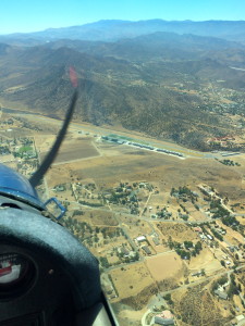
 Manuel flew out, with me handling comm. We got flight following at 6500′, which meant cresting just over the mountains and then descending. As we got close, SoCal suddenly told us that “runways 22 and 4 are closed at Agua Dulce” which are, of course, its only runways. Manuel decided to overfly it anyway. We got right over it and SoCal said that the closure actually would start the next day, so we were able to land. Unicom was deserted, but we could see the windsocks and runway 22 seemed appropriate, so Manuel did a teardrop and came in to land on 22. At right is the view you have entering on the 45 for 22.
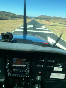
 It’s a bit of a hairy approach. There is rising terrain to the northeast as you prepare for your base turn, so you’re flying right at the hills while judging your altitude and distance from the runway (although it isn’t nearly as bad as Flabob). Coming in steep is a help, and a smooth 180-turn descent is probably more appropriate than a regular rectangular pattern. Then you’re on final and whoa, this runway is NARROW! As you can see, the numbers barely fit! There is also a significant downhill grade which feels very odd when you take off.
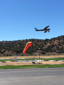
 The airport and runway are very nicely maintained, aside from the lack of taxiway markings from the runway (they can zip past before you notice them if you aren’t prepared!). The hangars are a beautiful deep red color. I found out later that it was to be closed for filming, and I can see why. While we were there, another plane fueled up and then took off. It was very shiny (aluminum?). You can also see a beautifully vivid windsock (one of three) and a wind tee on the ground (that’s the segmented circle).
We swapped seats and I did a loop around the pattern for practice. I went much too wide trying to avoid the hills to the northwest; a tighter pattern would allow you to come in before the hills and be immediately on (tight) downwind for 22. I landed, got off, and then taxied back, and took off to depart to the southwest (honoring their noise abatement request for 10-deg right turn after takeoff – although that heads you to the hills so it feels awkward). I flew back at 5500′, going around the mountains so a bit less direct than Manuel’s trip out. Manuel handled comm for me. It’s nice to team-fly; it allows you to focus more on flying the plane!
This plane just got some new avionics (ADS-B transponder) which among other things gives you traffic information on the GPS screen. On the way back to El Monte, I was just about to begin my descent when I noticed a plane seemingly heading straight towards us but 700′ below. The EMT tower announced the traffic to us, and we scanned for it but couldn’t find it. (Air quality is still poor from the recent fires, and there’s a lot of haze.) I delayed my descent to stay well above it. Then we got an audible warning from the avionics about this traffic! That was kind of cool. We finally spotted it ahead and off to the left, below us, and then I was able to descend.
Since we were a bit high on final, I got down to idle (still high) and went into a slip. Just a few seconds later we were on the glideslope so I came back out of the slip and proceeded with a short-field landing (full flaps). Yes, the flaps would have been enough to get me down as well, but it was a good chance to practice slips (it’s been a while!).
I’m up to 12 L.A. area airports now. Many more to go!