When thunderstorms get in your way

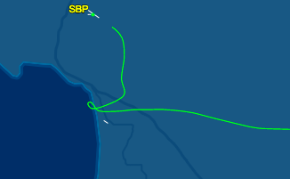
On July 6, I flew myself to Palm Springs. This is a short hour-long flight that takes you just outside of the L.A. basin. It turned out to be a record-breaking hot day across SoCal, so the primary things on my mind were keeping the engine cool enough to function and assessing the impact on airplane performance. Palm Springs is only 476 feet above sea level, but given the forecast high of 118 F (!), the density altitude would be above 4000′! (Here’s a handy density altitude calculator.) That means that the airplane would perform as if it were trying to land/take off from an airport at 4000′ elevation. Definitely something to factor in (faster ground speed on landing, longer landing roll, longer takeoff roll, reduced climb performance, etc.).

During preflight, I discovered that the plane’s landing light wasn’t working. I wouldn’t need it for my outbound flight, which was in the morning, but it would potentially constrain my options for a return flight. I decided to proceed and marked it INOP.

I got flight following to Palm Springs at 5500′. I was keeping a close eye on the engine cylinder head temperatures (CHTs), because it was so hot. To keep these values low enough, I had to throttle back and lower the nose, and I was only able to climb at about 150 fpm. In retrospect, I’m thinking that it might have been wiser to not take the plane out on such a hot day!

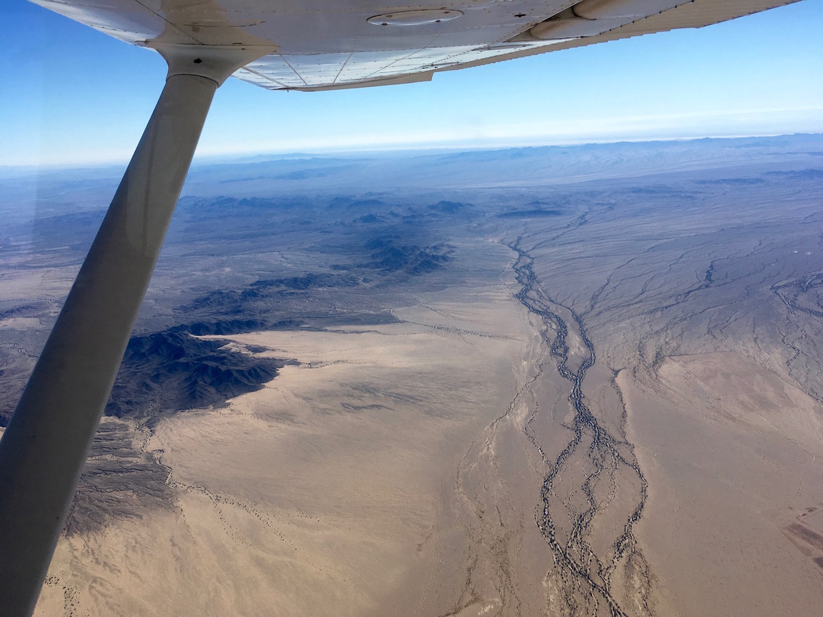
Along the way, I saw a fire burning at the Cajon Pass. SoCal ATC was busy calling traffic alerts with lots of mentions of firefighting aircraft, which were taking off from San Bernardino. They were all well north of my path.

When checking NOTAMs before my flight, I learned that PSP had changed their ATIS frequency from 118.25 to 124.65 as of May 31. Curiously, the official airport diagram (updated June 21) still had the old frequency. As I got closer, I checked both frequencies until I came through the Banning Pass and could finally pick it up – and sure enough, it was the new frequency. I was glad I’d gotten the NOTAM! Especially when I tuned in and heard that it was 46 C at PSP. I’ve never before heard an ATIS temp in the 40s!


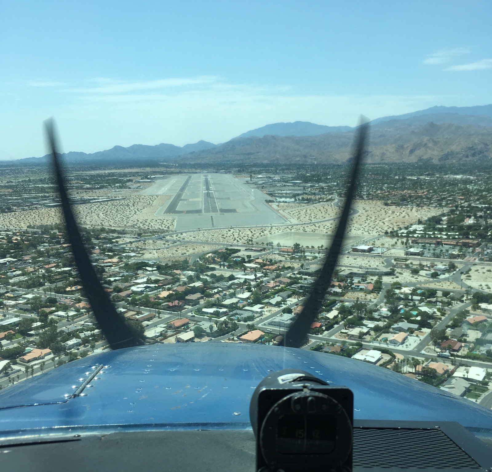
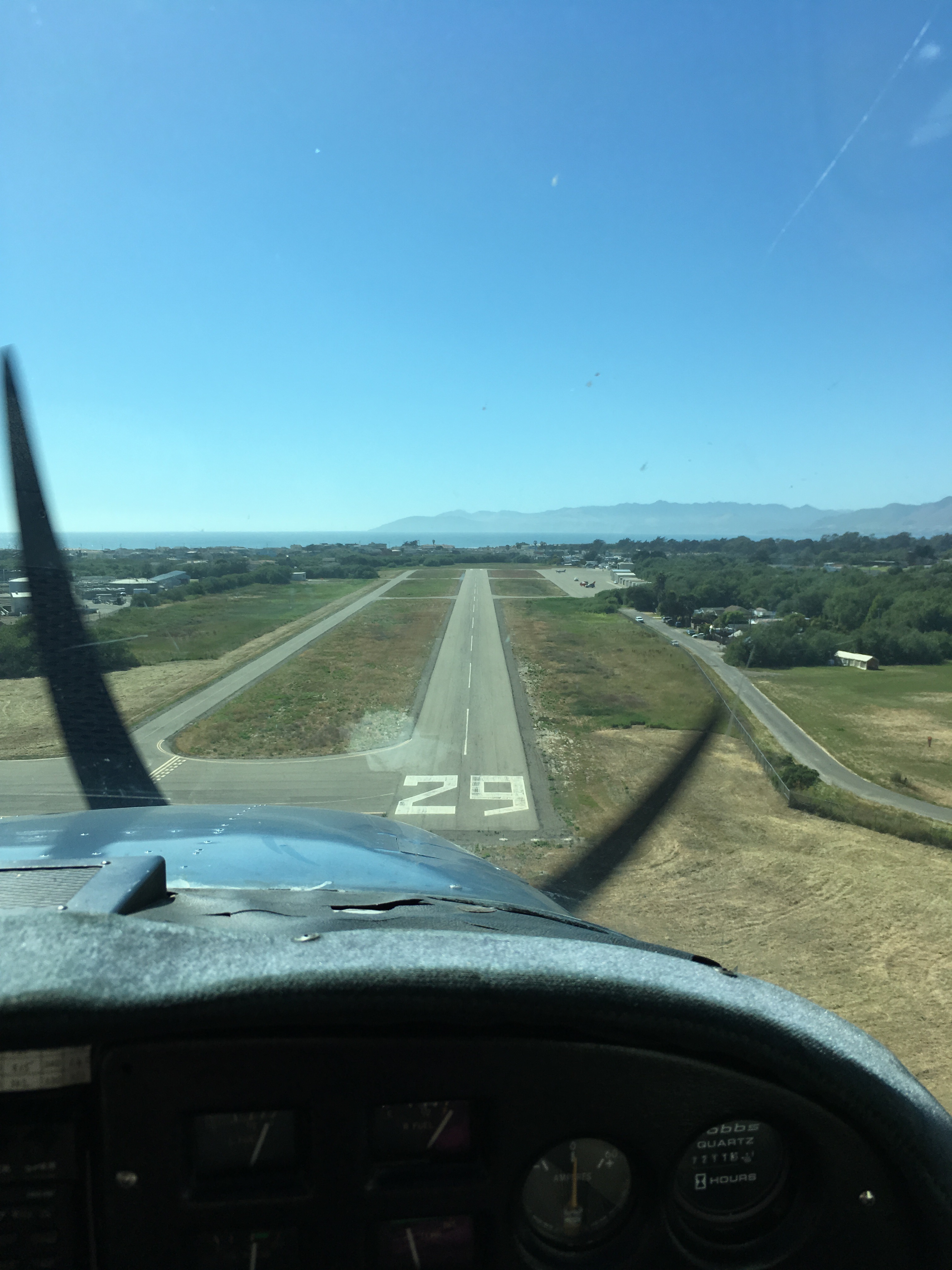
Final approach to runway 13R at Palm Springs

Palm Springs airport was dazzlingly bright and empty. The tower gave me my choice of runways, so I took the big one, 13R (10,000′ long! Why not?). It has a 3000′ displaced threshold, so it feels like it takes a looooong time to get there on final. :) In my flight planning I’d learned that it’s a common mistake to think that the second dark strip to the left is runway 13L. It’s not! It’s a taxiway. I’m glad to learn from others’ tips this way.

I had a nice landing and then was told to “roll out” to taxiway B at the other end, which also took a long time. In this case, landing long (to end up closer to the exit) seemed like a bad idea since if I needed a go-around, I would want all the runway I could get. I parked and got to enjoy a very nice FBO experience. I even got to cool off with a post-flight swim! First time I’ve visited an FBO with a pool!

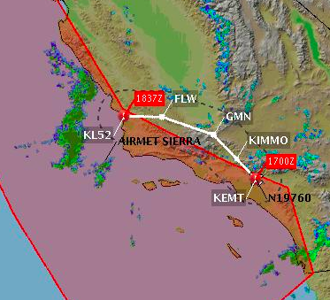
For my return flight, things got a little more interesting. I had planned to fly back on the afternoon of July 7. Waiting until the evening would be better, when it would be cooler, but since the landing light was INOP, I had to get back before sunset. On the morning of July 7, I found that thunderstorms were forecast for the afternoon. There was also a big TFR over San Gorgonio, where another fire had started burning. This was also (just) north of my intended route, but it could mean worse visibility due to smoke.

By midafternoon, the METARs were getting hairy, with TS (thunderstorms), LTG (lightning), CB (cumulonimbus), and TCU (towering cumulonimbus). From what I could deduce, a thunderstorm with lightning was raining on Ontario (just north of my path) and cumulonimbus clouds were squatting over March (just south of my path), likely with associated turbulence and up/down drafts that can extend 20-30 miles out, exactly where I would be flying.

These conditions were a clear “do not fly” signal. So I decided to stay an extra night and fly home in the morning, when it would not only be cooler but also be before any afternoon atmospheric drama would develop. Even when rationally you can clearly see that the right decision is to cancel, it still takes (maybe always will take) an effort! But as a bonus, I got to spend more time visiting family, seeing The Incredibles 2, and having a lovely dinner.

The next morning, it was “only” 99 F when I took off. I was assigned runway 13L this time (the short one), which I determined was still long enough (4952′) for my needs. I expected to depart left traffic, but curiously I was told to make right traffic. It felt weird to turn and keep climbing over the departure end of 13R, but I assume there must have been some traffic east of the airport they wanted me to avoid. As I climbed, another plane called in complaining that they couldn’t get the ATIS, and the tower told them about the month-old frequency change. Now I’m wondering if this is a test to see who is actually reading NOTAMs?

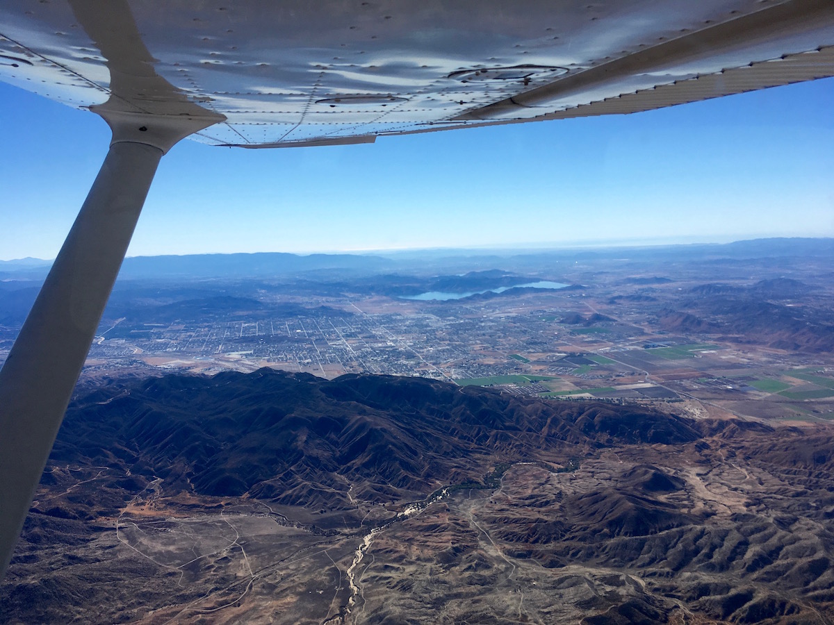
The tower asked me to follow highway 111, which leads northwest away from PSP, at or below 3000′. He seemed happy that I knew where this highway was and could comply. Eventually he handed me over to SoCal and thanked me for my “help” (I still don’t know what he was having me avoid, but happy that he seemed happy). I came back through the Banning Pass, slowly climbing to 4500′, and then SoCal asked me to divert north around Ontario’s airspace. I had planned to go south via PDZ, but okay, I obligingly turned north and spent some time fiddling with the GPS to change my flight plan. In retrospect, I think I could have just communicated that I was heading to PDZ and that might have been fine – they probably just wanted to keep me out of the busy part of ONT’s space. But this way I got to fly over the San Bernardino airport (see left).

The rest of the flight was uneventful and I was home in time to quickly pack for a work trip to Sweden the next day!

Preparing for alternates pays off!

In June, I flew up the coast with my friend Sarah Elizabeth to visit the tiny Oceano (L52) airport, which is close to the ocean and also has good lunch options nearby. At that time, we were getting a lot of morning marine layer clouds over the coast, and after assessing the weather, I decided to fly an inland route to avoid the clouds (KEMT -> KIMMO -> GMN -> FLW -> L52). You can see my planned route, and the magenta polygon surrounding the coastal “airmet sierra” (cloudy) area, at right. Conditions were looking good after 11 a.m. for San Luis Obispo (KSBP) and Santa Maria (KSMX), which are directly to the north and south of L52 (which doesn’t have its own weather station). We took our time getting the plane ready to allow more time for the clouds to burn off and departed around 11:30 a.m.


[Picture by Sarah Elizabeth]

The inland route went very well. The airplane’s climb was lethargic because I was trying to keep cylinder head temperatures below 400F. It took 20 minutes to reach cruise altitude (8500′). However, it was smooth sunny sailing after that. In fact, it was clear the whole way until the very end.

As we got close to L52 at about 1 p.m., I could see a layer of clouds. That was vexing, since neighboring SBP and SMX were still reporting clear skies! A little bit of cloud was hanging RIGHT OVER the runway I wanted. Still, there was some hope. If the clouds were at least 2000′ above the ground, I could come in and land safely under them. So I kept descending in the clear area to the north of the cloud. Lower and lower… I got down to 1500′ and the clouds were STILL well below (and to the south of) us, so no go. I couldn’t believe it! We were just over a mile north of the runway, with clear skies, but the runway couldn’t be reached!


Clear to the right and beneath us, clouds to the left (where the runway is).
[Picture by Sarah Elizabeth]

I powered up and climbed over the ocean to about 2000′, circling. I was very glad that I had alternate plans all ready to go. I had the runway diagrams for both SBP and SMX at hand. I decided to divert to SBP (San Luis Obispo), and Sarah Elizabeth and I smoothly and calmly handled the diversion (she was handling comms the whole flight). Diversions can be stressful because you quickly have to change your plans, navigation, radio frequencies, etc., all while maintaining good control of the airplane, watching for traffic, etc. But this one felt like a piece of cake because we had everything we needed ready to go. Having a co-pilot is a huge help, too!


Beautiful coastline!
[Picture by Sarah Elizabeth]

After we landed at SBP, we found a very friendly FBO (Nice bathroom! Free ice cream! No landing fees!) and had a very tasty lunch at the Spirit of San Luis (ha!) restaurant. This flight also tipped me over 200 hours of flying experience! :)

Here is my path, starting at EMT in the southeast and heading up to SBP in the northwest. You can see the kink where we tried to land at L52 but then had to divert to SBP.

But look how close we got! L52 is the little white line just south of our track:

After lunch, we headed back with Sarah Elizabeth piloting and me handling comms. She did a nice loop around the KSBP pattern, and then we headed south. By this time, the clouds had cleared away from L52, so she got to land there! It’s a tiny little runway (2325′ long) and quite narrow (see picture at right).

As we taxied back to take off again, a huge heron flapped its way across in front of us. Wow! We flew south along the coast (since the clouds were more favorable) and got to see Santa Barbara, and then as we approached L.A., we saw a lot of cloud over the ocean that almost duplicated the coastline, which was cool. Then clear skies all the way inland to our home base at KEMT.

Trying out the impossible turn

Recently I completed my FAA flight review, which is required every two years. (It’s hard to believe that I’ve had my license for two years now!) This involved sitting down with my instructor to go over various flight regulations and knowledge topics (planning a cross country flight, airspace, interpreting weather products, etc.) and then going up in the air to put me through my flying paces. We did some takeoffs and landings, and then just after one takeoff he suddenly asked, “Now, if your engine quit right here, could you make it back to the runway?”

My brain sort of froze because this is NOT how we practice engine-out landings. I had just turned crosswind and was perhaps 700′ above the ground. This isn’t quite the worst-case scenario (that is when your engine dies before that first turn, while you’re still pointed directly away from the runway), but it certainly was unfamiliar and unexpected (just like a real emergency would be).

“Power to idle,” my instructor directed.

My stomach sank along with the engine’s RPMs as I began banking back towards the runway – the WRONG runway – the end we’d just taken off from. Meanwhile, my instructor got permission from the tower for this wrong-direction “teardrop” landing. There was an 8-knot wind pretty much aligned with the runway, which was perfect for our takeoff. According to the audio recording, I said, “You’re a crazy man, I’m landing with a tailwind!”

Him: “Yep, so, we’ll be ready for a go-around.”

I could see we were coming in high (high!) so I kept turning to make my teardrop into more of an S shape and give me more time to lose altitude. Flaps went in. It wasn’t enough. We went into a slip and that helped. And then we were close to the ground and I flared and we landed – a little long, but acceptable. Wow!

So, this wasn’t quite the impossible turn (in fact it was very possible). But doomed (i.e., fatal) attempts to turn back to the runway without sufficient altitude are a serious and continuing problem in aviation. The general advice is to pick a minimum altitude above ground (e.g., 500′, 1000′) below which, if the engine dies, you should NOT try to turn and should instead continue straight ahead.

I like this advice:

Before every takeoff, prepare yourself for a possible engine failure with a short briefing stating out loud what you will do if the engine fails on the runway, below your minimum turnaround altitude and above that altitude. Then make a quick callout as you climb through your minimum turnaround altitude. That way, if the engine fails on takeoff, your decision is easy. If you haven’t made the minimum altitude call, you don’t even consider turning around. Just get the nose down, keep the airplane flying, and look within about a 60-degree arc for the best place to set the airplane down. The bad news is that someone will almost certainly have to call your insurance company. The good news is that you will almost certainly be able to make the call yourself.

The idea is that an abort/failure briefing can help make emergency response actions automatic rather than slowed by disbelief and denial. It is also possible to practice the necessary turn, at higher altitudes and away from the airport, to determine how much altitude you’ll lose. I’ve done this, and it was quite interesting, but it lacks the scare factor and adrenaline rush and “the ground is right there” visuals of a real low-altitude engine failure. Better than nothing though!

It’s good to get to try new things with the support of an instructor. He noted that that was about the limit (in terms of minimum height above ground and maximum tailwind) in which he’d like to try that sort of thing. I translate that into my own personal minimums as: “Don’t try this at home. Yet.”

A solo diversion

My return from Phoenix to L.A. was a little more eventful than my trip out.

I departed the Mesa Gateway airport at 12:30 p.m. with an intersection takeoff from runway 30L. I was busy for a while as I climbed to get above KCHD (Chandler)’s airspace (which goes up to 3000′) but stay below the Phoenix Bravo (starts at 4000′). I contacted Phoenix Departure and got flight following, plus a bonus clearance into the Bravo without even asking! That simplified my route quite a bit.


Inside the Phoenix Bravo!

Most of the flight back (cruising at 8500′) was uneventful. I played around with the GPS some more. I read the map. I updated my nav log. I scanned my instruments. I crossed the Colorado river.

From my weather briefing that morning, I knew that there were some low-visibility areas in the L.A. basin – which often arises from the marine layer, which burns off by midday or early afternoon, and usually it doesn’t extend as far east as El Monte anyway. However, just in case, I had backup plans.

Three hours after departing, I entered the L.A. basin, where I discovered a soupy haze starting around Ontario. Yuck! The SoCal controller told me to report when I had (weather) information Foxtrot from EMT. The news wasn’t great; EMT was reporting 3 statute miles visibility. So there I was (over PDZ), flying about 100 mph towards a destination that was dicey. Three miles visibility is (barely) legal for VFR flight, but it is considered “marginal”, which is not a good thing. Rick Durden, in his excellent The Thinking Pilot’s Flight Manual, quoted Terri Watson saying,

“Anything to do with marginal weather means the pilot has to understand deep inside that she or he is entering a statistically significant realm where he or she is likely to wreck an airplane and kill or injure people.”

I also couldn’t help remembering a conversation I’d had with my mom that morning when I explained what “personal minimums” are. My personal minimum for daytime VFR is 5 miles visibility. And yet… even so… for a brief moment I was tempted to push onward to EMT. The drive to continue your planned flight is very powerful!

Information Foxtrot from EMT was 45 minutes out of date. I asked the SoCal controller if there was any update. I think he called the tower directly for me. He came back a few seconds later and said they still said 3 sm vis. I took a breath and said I would divert to POC. I had checked their ATIS too, and despite being only 10 miles from EMT, they were reporting 10 sm vis (better conditions than CNO as well).

I headed straight there, cutting through Ontario’s airspace. I don’t have any more pictures as I was busy flying the plane. :) As I approached POC, conditions seemed worse to me than 10 sm vis, but way better than 3 sm vis. Thank goodness I was familiar with the area, although I’d never approached POC from the southeast. I got cleared for a left base to runway 26L and spotted the traffic ahead of me. Then on final they told me to switch to 26R to allow an IFR departure. 26R is shorter, but I’ve landed there before so I went ahead and sidestepped to the right. (Had I not felt good about that, I could have said “unable” and presumably they would have worked around it or told me to go around).

After landing, I took a minute to collect myself. I definitely was feeling the increased mental effort from the diversion, the low visibility, and the last-minute change in assigned runways. But I made it on the ground, safe and sound! I taxied over to the transient parking area and shut down and tied up the plane. I went in, took a break, checked the weather, and called for fuel.

By the next time the weather reports updated, EMT was reporting 7 miles visibility, so I went for it. I got the plane ready, only to then discover that POC was now reporting 3 sm vis! It didn’t appear to be noticeably worse than when I’d landed, and I knew that I should be heading towards improving conditions, and also that if I took off and didn’t like it, I could turn around and land again. So I decided to proceed.

After takeoff, I climbed to 2500′, which was above the haze (nice!). However, the ground wasn’t easy to see. Once again, familiarity with the area was a boon. I transferred to the EMT tower and spotted traffic they called off my right. As I came around to final I noticed that the PAPI (glideslope light) wasn’t there! No matter, I don’t need it to land, especially at EMT. Touching down that afternoon was my 500th landing, and it was an excellent one!

Overall, it was a good experience that made me work a little harder than is typical in sunny southern California. (With conditions like that, I probably wouldn’t have bothered to go flying for fun.) Here are my reflections:

  • It’s possible that I could have made it fine to EMT on the first try, but it’s also possible that I could have ended up in deteriorating conditions, disoriented, or worse. The fact that weather reports come out only once an hour is pretty limiting. (They can be updated more frequently, but you cannot depend on that.) I’m glad that I opted to divert. I’ve wondered if I would have the strength to resist get-there-itis if I were solo and needed to make that judgment call.
  • Personal minimums are VERY useful. The whole point is that you’ve thought about your comfort zones and skill levels in advance, so that in the moment you don’t waste time trying to assess risks and (most likely) rationalize a potentially dangerous decision. Arguably, my second takeoff was less well advised, but I’d had time to think it through on the ground, and I felt good about the decision.
  • POC is a great alternate destination for EMT if there’s some reason that EMT is unavailable or closed. It is not really a great weather alternate since the two airports are so close together and therefore likely have similar weather. It worked out well for me in this case, but a safer bet would have been Riverside or San Bernardino. Since I was coming from the east, I knew conditions were better the farther east I landed. But farther east would be progressively more inconvenient, and I definitely felt the pressure of wanting to get closer to my destination if possible!
  • My ongoing project of landing at all of the L.A. airports has real utility! Having visited other airports makes it that much easier to confidently divert to them even if they were not your intended destination. Banning, Flabob, Chino, and Corona were all additional options that I had previously visited.
  • It really is true that when things pile up, even if each one isn’t a big deal, just mentally dealing with a longer list (plus uncertainty) is fatiguing and that in itself is a risk factor. When I took off the second time, I was refreshed (and my plane had full tanks). I felt much more sharp and capable, and I had plenty of options if needed.
  • Yes, I reported that the PAPI was out after I landed at EMT. Another pilot on the ground chimed in to confirm, so it was good to hear that I wasn’t imagining things. ;) (And EMT was able to send someone out to check it.)

Next adventure? Bring it on!

Solo flight to Phoenix

For Thanksgiving, I flew myself from L.A. to Phoenix. It’s about a 3.5-hour flight in a Cessna 172 – long enough to make for an interesting cross-country planning exercise and good practice for me solo!

I departed the El Monte airport at 11:17 a.m. with flight following to my destination, the Mesa Gateway airport (KIWA). Initially I got an altitude restriction of 2500′, which progressively stepped all the way up to my cruise altitude of 9500′.

Diamond Valley Lake
Looking south towards Diamond Valley Lake

The SoCal controller asked, “What is your route of flight to Williams?” Since I had gotten this question on my flight to the Grand Canyon, this time I was ready to answer!

“Palm Springs to Thermal to Blythe to Buckeye to… Gateway!” (i.e., not “Williams”)

“Oh yeah,” said the controller. “I forgot the name.” Later I learned that KIWA used to be called “Williams Gateway airport” which helps explain why this controller (and another one along the way) used the other name.

Banning Pass
Approaching the Banning Pass

Near the Palm Springs VOR, I got a traffic warning for a jet passing by (“caution wake turbulence”). I looked out to the left and saw a jet climbing past, a healthy distance away. I reported the traffic in sight and was told to “maintain visual separation.” I watched it climb up and away from me (fast!) and decided it was okay.

I then spent a couple of hours droning my way east through the desert sky. I scanned my instruments. I updated my nav log. I drank some water. I played with the GPS (good time to explore new features ;) ). I fought off the hypnosis that comes from nothing happening in a fully trimmed plane and no adverse conditions and very little traffic on the radio.

Most of the desert looked like this:

Desert

At Blythe, I crossed the Colorado river:

Colorado River

As I got close to Phoenix, things started to happen (and I got too busy to take pictures).

Luke Approach asked me, “When will you begin your descent, and to what altitude?”

“I was planning to descend at Buckeye, but I can start now, descending to 5500′, or a Bravo transition if possible?” (This would allow me to go more directly to KIWA, which is on the other side of Phoenix.)

He told me to stand by, then: “Descent approved, switch to Phoenix Approach, expect a Bravo transition.”

But my celebration was short-lived. I switched to the other frequency, which was suuuper busy. The controller gave me a right turn for traffic and told me to remain clear of the Bravo. I complied. I continued my descent and kept an eye on the mountains (alt 4600′) as I drew closer and closer (around 5500′).

Finally I said, “678 requests left turn to avoid terrain.”

Controller: “678, negative, maintain heading.”

This was rather vexing. I could of course go higher to clear the mountains with more margin. But just to the east of the mountains, the Phoenix Bravo airspace begins at 6000′. So if I got higher than that, I would have to be ready to dive under it, and that seemed like a bad set-up right over the mountains. I continued thinking about it and climbed up to 5900′.

Finally I got switched to new controller who was more accommodating (or less busy). I requested a direct turn to Gateway (I was still heading southeast thanks to the earlier controller!) and was approved. I soared over the mountains and carefully slid in under the Bravo airspace. I then had to continue stepping down to stay under it. I got traffic alerts a couple of times to help spice things up more. Then I had to cross over the Chandler airport’s airspace (goes up to 3000′) while staying under the Bravo (which goes down to 4000′ there). If you think this is stressful while you’re watching for other airplanes, navigating an unfamiliar area, and remembering to fly the plane (airspeed, engine status, throttle, enrich that mixture!, pre-landing checklist!), you’re right.

At last I got handed over to the KIWA tower. Home free! Except not. I got assigned a right base entry for runway 12R, which was exactly what I was anticipating given the winds. Then:

“678, converging traffic, same altitude, suggest you climb.”

Argh! I turned my descent into a climb (mindful of that 4000′ Bravo!). After a bit, the tower informed me that the traffic had passed behind me. He instructed me to “continue east, we’ll fit you into the right downwind.” This was kind of handy since by then I would have had to work pretty hard to get down to pattern altitude (2600′) before reaching the airport. But it was also tricky because I was then heading southeast and would need to set up for a northwest downwind prior to a right turn to 12R. This is easier to see with a picture:

PHX trackThe green line is my radar track.

I landed neatly just after the threshold for 12R… then had to roll a looooong way to get off at taxiway H. By that I mean something like 3000′ of putt-putt-putt down the runway. Next time I will land longer. These 10,000′ runways are huuuuuge for a little Cessna!

Maybe not so huge for these guys, who landed right after me:

Jets at KIWA

Great flight, all told!

« Newer entries · Older entries »