Flying “under the hood” to another airport (no peeking!)

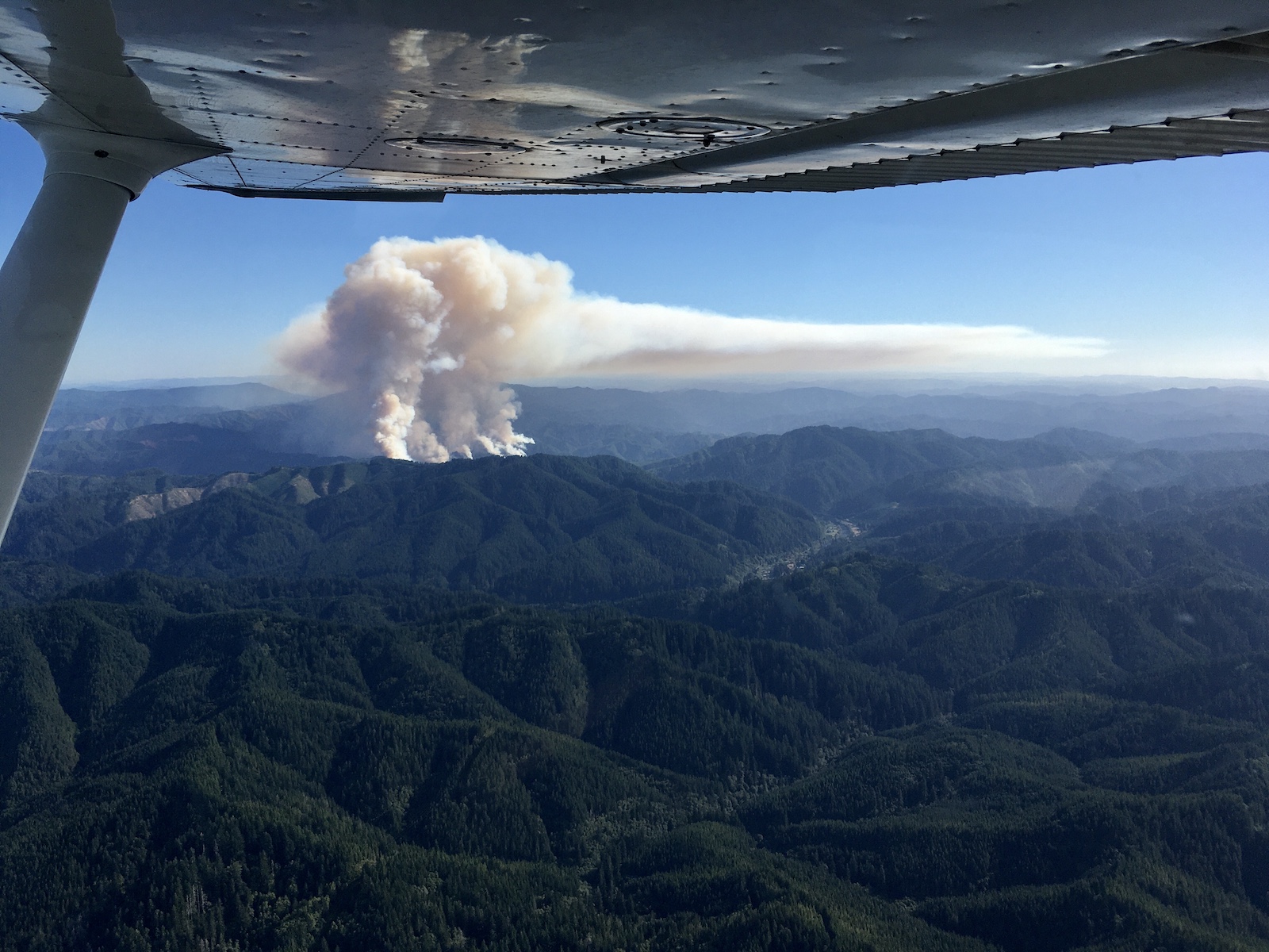
For my second instrument training lesson (August 14), I got to fly to another airport wearing a “view limiting device” that blocks all peripheral vision so all you can see is the instrument panel in front of you. Your view is something very like this:


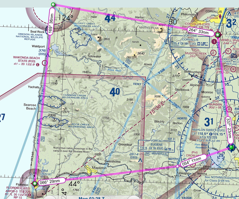
For this flight, we took off from Corvallis (KCVO) and flew to a nearby intersection in the air (SHEDD), then turned south for our destination, Hobby Field (Creswell, 77S).

I had filed the flight plan beforehand, and we got our clearance to 77S in the air. I then learned about the next step, which is to get the current weather at 77S and then request a particular approach to your destination. In this case, we asked for “the RNAV 16 approach to Creswell, to full stop, starting at ALFOR.”

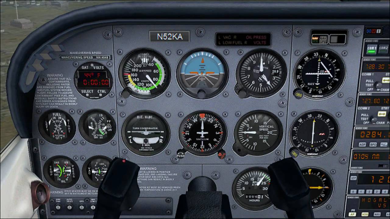
While heading to ALFOR and maintaining your course and altitude and airspeed and five other things, you brief (talk through) your approach. One mnemonic to help you along is MARTHA:

  • Missed approach: what to do if the clouds are too low for you to land (or winds or turbulence or any other reason you’d rather not do it right then)
  • ATIS (weather) and Altimeter setting
  • Radios set so we can talk to the right people and navigate to the right destination
  • Time: in case it’s a timed approach (this one isn’t)
  • Heading: to get aligned with the final approach, 159 degrees (southeast)
  • Altitude: start at or above 3800′, then descending as indicated on the approach plate

At ALFOR, you begin following a series of named waypoints that allow you to get progressively lower until you can line up and land. These all have 5-letter names, and the RNAV 16 approach sequence begins to feel like a magic charm: ALFOR, IYAYE, WOSLO, ZEMAM, UWZAB. Somewhere after here, my instructor declared that we’d broken through the “clouds” and I could remove my hood and land the plane. The approach brings you in lined up for runway 16 (headed south), but the wind was from the north, so we did a “circling” approach, which just meant flying into the downwind for runway 34 and landing normally. If the clouds don’t magically clear before you descend to (in this case) 1041′, you execute the “missed approach” to fly away and either try again or go elsewhere to land.

We departed using the HOBBY TWO obstacle departure procedure, which is designed to keep you safe from the surrounding hills (although note the extensive list of trees, poles, fences, etc.!). I put the hood on while we were climbing out, so I couldn’t see the hills anyway. (Which is okay because my instructor was watching them carefully :) ) We then flew back to KCVO, along the way requesting the RNAV 35 approach there. The associated magic incantation is DERAY, WENKA, ACOTY, CESDO. This time we flew the approach from DERAY, then pretended that we were still in clouds so did the missed approach back to DERAY, and flew it again.

Flying with the hood on is challenging. It took all of my concentration to try to keep the plane on the heading to the airport, descending at the correct rate, good airspeed, etc. There’s so much that you subconsciously process and respond to when you can see the world outside your plane! When that is taken away, you have to stare at the dials and reconstruct your spatial position and trajectory and translate that into the right control adjustments – pitch, power, bank, and rudder. On our first approach to runway 35, I ended up offset from the actual runway (when finally allowed to look!), but the second approach was much better (and that’s the one we landed from). I’ll keep working on refining it!

Flying by instruments and circling in the sky

I’ve begun training for my instrument rating as an airplane pilot, and it is SO FUN! I’ve been flying since 2014, and those skills are an important base to start from, but in some cases it’s like learning to fly all over again. An instrument rating qualifies you to legally fly through the clouds even when you can’t see outside your airplane. If you stay current and sharp with your instrument and aircraft control skills, you can do it not only legally but also safely. :)

My first instrument flying lesson was fantastic. We started with an introduction on how to file an IFR (Instrument Flight Rules) flight plan and to obtain a “clearance” from air traffic control that enables you to fly that plan. We filed the flight plan by phone (good practice since I usually file my VFR (Visual Flight Rules) flight plans online). The plan was simple: depart CVO (Corvallis airport) using the SHEDD4 departure procedure to the SHEDD intersection, then return to CVO (via an approach to runway 17 which means going north first).

Aviation map of flight

Aviation map showing route from CVO (lower left) to SHEDD (right) to INNOP (top) and back

We taxied to the runup area and requested our clearance to depart. They gave a clearance, “void in 5 [minutes]” and as I acknowledged it, they amended it to “void in 2” so we expeditiously turned to the runway and took off. The whole flight was done on a sunny clear day, to gain experience with the procedures and develop spatial awareness while I can still see outside the plane. Next time, we’ll do it with blinders on!

The SHEDD4 departure procedure has you take off and do a climbing left turn to intercept the 081 radial (a bit north of due east) from the CVO VOR (a radio beacon). You follow this radial out to the pre-defined SHEDD intersection and “hold” there. SHEDD is an invisible point in space defined by the intersection of specific radials from two VORs (in this case, CVO and Eugene (EUG)).

I had little idea how to fly a “hold” (oval in space, anchored by SHEDD), but in addition to instruments that receive the VOR signals, we also have a GPS receiver, and it knows about SHEDD and how to fly a hold. In this case, coming in on 081 to a hold defined on the 360 radial from EUG, we executed a parallel entry. This may sound pretty jargony, but it’s not that complicated. We basically followed path #2 in this diagram (if you assume north is down here):

Initially the hardest part for me was that the air traffic controller kept telling us about other airplanes to watch out for, and I was trying to look for them and manage the instruments and plane all at once. Fortunately, my instructor took over watching for traffic and encouraged me to focus entirely on the instruments (which normally is a no-no in regular VFR flight!).

We flew around this oval (often called a “racetrack” but you’re the only one in the race) a few times and it was great fun. You’re aiming for precise turns and precise headings, while maintaining your altitude and airspeed. As you get better at this, apparently a hold can actually be a break during which you can plan your next activities (if you need some planning time).

We then flew out to do an instrument approach to the Corvallis airport, which is entirely different from how I approach in visual conditions. We went to another intersection (INNOP), flew a “procedure turn” to get lined up, and then flew an RNAV/GPS approach to runway 17. This kind of approach gives you vertical and horizontal guidance in the form of little white needles that form a centered cross when you are descending correctly in the right direction. If you drift left, right, up, or down, one of the needles also moves and gives you visual feedback on how to correct it. We got down close to the airport and then landed normally.

What a fun beginning! It feels like I am peeling back a layer of reality to see under the surface to a whole new world of instrument procedures. It reminds me of the feeling when I discovered geocaching (there are secret treasures everywhere!), or even when I started flying airplanes and realized there were little airports all over the place (the L.A. basin has 25+) and also pathways and patterns in the sky. All of this activity and organization going on, and it’s invisible until you start looking and learning about it. More, please!

NOTAMs are now Notices to Air Missions

I recently discovered that the FAA term “NOTAM” (the acronym for Notice to Airmen) changed to stand for Notice to Air Missions in December of 2021. NOTAMs are useful information prior to conducting any flight; they can warn you of closed runways, firefighting activity, aerobatic activity, equipment that is out of service, and more. I always find it kind of amusing (and archaic) to be referred to as an “airman”, and it’s great to see that the FAA is catching up with the fact that not all of us are men. The first female pilot to receive a license in the U.S. was Harriet Quimby in 1911… 110 years before this change. As of 2021, there were 64,979 female U.S. pilots, of 720,605 total (9% female).

NOTAMs are useful, but regrettably cryptic in their language (e.g., “WI” means “within” and “U/S” means “unserviceable”). Recently I planned a flight with a friend to the Salem airport for lunch. Included in the NOTAMs for Salem that day was:

AD AP ARFF INDEX A NOT AVBL AND AP CLSD TO AIR CARRIER OPS

I did some googling and searching to finally figure out that this meant that certain firefighting equipment was not available, so “air carrier” operations were not permitted (but general aviation, my kind of flying, was). This was puzzling because Salem doesn’t have any air carrier (commercial) operations. Because flying to an airport that is closed is generally a bad idea (not to mention embarrassing), I called the Salem airport manager to be sure I understood the NOTAM. He confirmed that I could still fly in, and mentioned that they are required by the FAA to post this NOTAM even though they have no commercial service. In this case the (irrelevant?) warning just led to a lot of extra questions and effort – but maybe it is useful if an airline flight has an emergency and is trying to decide where to land? I dunno. It also occurred to me that even as the pilot of a small Cessna, I too might want to have firefighting capability present if I needed it… :) However, my flight was uneventful and the lunch was fun!

Now that they’ve updated NOTAM, perhaps they’ll find a way to update terminology for the pilot’s license (actually a certificate) itself. I likewise find it amusing and quaint that I hold an Airman’s certificate to fly a plane.

Touring the Oregon coast

Today I went on a tour: out to the coast, south, and back inland.

I started in the northeast corner (Corvallis), flew west to Newport (KONP), then flew south to Florence (6S2), then inland to Eugene (KEUG) and back north to Corvallis. Amusingly, none of the endpoints are at least 50 nautical miles apart, so none of this counts as “cross country” flying :)

From Corvallis, I flew west over forested hills towards the ocean. Winds at Newport were sporty: blowing from 320 at 14 knots gusting to 19 knots. My runway of choice was 34, and that meant landing from its west side (left traffic), so I crossed over midfield well above pattern altitude and headed out to sea:

It felt kind of strange to fly out towards the ocean and then start descending towards it, with the runway at my back. But that’s what you need to do: fly across, descend in a right turn to enter the left downwind for runway 34. When I reached downwind I could really feel that north wind pushing me along to the south! I turned base and it was actually a little dizzying as I was banking and turning in the air but the entire air was moving south, so it looked like the ground was sliding to my left (which it was). I crabbed across base and turned final, adding a few extra knots for the gust factor. I landed neatly and then had a long taxi down the runway to the first place you can exit. :)

I taxied back to depart on runway 34. I took off, turned left, and here is the view looking south:

I had a very lovely flight south along the coast to Florence. Sunny, waves below, sandy beaches and rocky beaches – delightful! At Florence, however, the winds were even stronger: blowing from 330 at 18 knots gusting to 26 knots. The runway was well aligned (33), but that’s a lot of gusting. A Cherokee was ahead of me and I hoped to benefit from their experience. In fact, after they landed and exited the runway, they kindly warned me of “strong winds on final”. I continued down and prepared to land. This time turning base was even more exciting because I started encountering bumpy air. Final was even wilder, with sudden bumps up and down, airspeed oscillations, and even being shoved to the side and tilted. I didn’t like the approach, so I did a go-around and came back to try again. The second time, the same thing happened, and I went around again. The third time I got a bit of smoother air, and I was hopeful, but then a crazy downdraft, weird tilt to the right, and airspeed varying between 85 and 65 knots was enough for me to throw in the towel. If you can’t get a stabilized approach, it’s not worth it. So I departed for my next stop and will have to visit Florence another time!

As I departed, I flew past this breathtaking forest fire. (You can clearly see what the wind direction is!)

I diverted around the fire and flew on to Eugene, where I was treated to… a towered airport! Wow, it felt like coming home. The winds were from 360 at 14 knots gusting to 19 knots (landing runway 34R), similar to Newport, and I didn’t have any trouble with it. I then taxied back to take off again… this time behind a massive Delta jet! (Wow, it felt so nice to have a ground controller as well!) I departed to the north for Corvallis and had a short, uneventful flight home. Another lovely day of flying in Oregon!

Visiting an aviation museum, by plane

The best way to go!

On Saturday, I flew from Corvallis (KCVO) to the McMinnville airport (KMMV), about 50 miles to the north. It was my first flight to a new airport since moving to Oregon. I was very excited to get out and explore from the air! It was a beautiful sunny day, with a nice bit of wind for takeoffs and landings (10 knots). I completed my engine runup, held short for a helicopter that was landing on a taxiway and kicking up dusty vortices, and then I was off. Flying solo, I got a great rate of climb! I headed up to 4500′ and then called Cascade Departure to request flight following. (I understand local pilots mostly don’t bother, but I love flight following! More information is always good, and if something went wrong, I wouldn’t have to fiddle with the radio to find someone to talk to.) After just a few minutes, they handed me over to Seattle Center as I traveled north.

The left picture shows Corvallis (OSU’s Reser Stadium is a good landmark with its red margins), and the right shows Mt. Jefferson in the distance. I hope to get closer someday!

As I approached McMinnville, I started making radio calls and listening carefully to the plane and helicopter activity. The wind was from 030 at 8 knots, so I planned for runway 4. I crossed over midfield at 1000′ above pattern altitude (apparently folks here prefer 1000′ to 500′, and I’m happy to have more buffer). This airport is tricky because it has two intersecting runways. The wind primarily favors one at a time, of course, but often both are in use anyway (e.g., to do instrument approaches). I’m still trying to find out the best way to handle this (all runways at this airport use left traffic, which seems like a problem to me if two are in use) – I asked a local pilot and he said he just does an extra-wide pattern to try to minimize conflict. Ugh! I miss control towers already :)

Anyway, so I crossed over at midfield and then did a “teardrop” descent to turn around and enter on the 45 for the left downwind for runway 4. Here is what it looks like from the air. I annotated the runways, so you can see that I’m coming in perpendicular to runway 04-22 (and looking and listening like mad for anything happening with runway 35-17).

I landed fine and taxied to the transient parking area, which had tiedown chains all ready!

One of the great things about this airport is that there is the amazing Evergreen Aviation and Space Museum just across the highway! Normally they offer a shuttle from the airport, but when I called, sure enough, no shuttle now due to COVID-19. The museum itself was open, though, so I hiked over (very glad I brought my hat!) and then spent 1.5 hours happily browsing the collection. So much great information and so many great machines! Here I am with the Spruce Goose, which was carefully transported here from Long Beach, CA:

They also have an outstanding history of space flight side of the museum – I could spend many more hours here. There were no crowds and it was very easy to stay far from the few other museum-goers.

I then hiked back to the airport and prepared to return. The winds had shifted a little, so now runway 35 was primarily in use, so I figured out how to taxi there, which involved taxiing across runway 04-22. I reached runway 4 (resisting the urge to announce that I was holding short, which apparently isn’t done at untowered airports) and noticed that a helicopter was landing on the runway (so both were indeed in use!). I waited until the helicopter was clear and then quickly taxied across runway 4. I took off on runway 35 and climbed back to 3500′ for my return, again with flight following. Back at Corvallis, I did another cross-over-midfield-into-teardrop (good practice for me since I rarely had to do this maneuver in SoCal!), landed, and taxied back to the hangar. A delightful day of flying and museum-going altogether!

« Newer entries · Older entries »