Flying IFR to Aurora

On May 27, I flew with friends up to the Aurora State Airport (KUAO) for a safety seminar. It’s about a 30-minute flight each way. I’ve never actually visited the town of Aurora on the ground, but I’ve flown to the airport many times. Willamette Aviation does a wonderful job of bringing in great speakers and also serving treats like ice cream and pie – and for this event, a full BBQ!

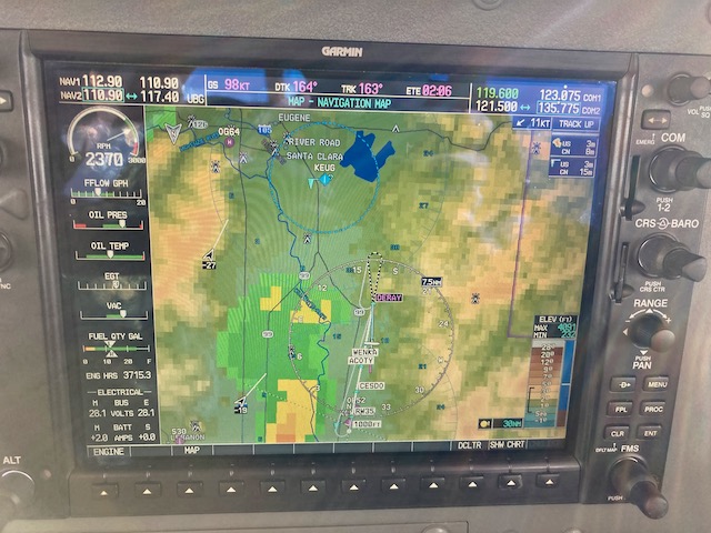
By default, we planned to fly there VFR (visually). But when we gathered at the airport, the cloud ceiling was only 1500′ above the surface. No worries, perfect chance to exercise that instrument rating! We had five people going in two planes, with one instrument-rated pilot per plane. I filed KCVO DUBMY KUAO to set myself up for the RNAV 35 approach to KUAO, but ATC came back with KCVO CVO V495 UBG KUAO at 6000′, a longer route that would take us north before coming back south to make a northward landing. I hoped they might give us a shortcut along the way.

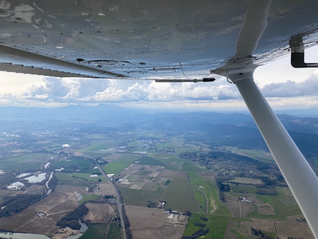
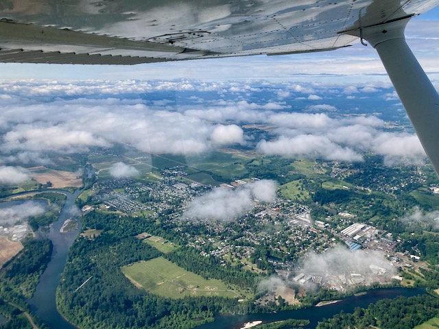
I was flying the slower of our two planes, so the faster one departed first and then we “held for release” until they were clear of the airspace and Cascade Departure cleared us to take off. The clouds were now at 1900′ above the ground. We climbed up via the SHEDD4 departure, punched through the clouds (which were only a few hundred feet thick) and then were on our way north. The clouds below us got thinner and I had this beautiful view:

Our lead plane was vectored off of V495 with the hoped-for shortcut to the RNAV 35 approach to KUAO. We were left tracking V495 much longer, but our vector finally came and we got to head over to execute the same approach. After joining the final approach course, we punched down through a thicker cloud layer, then executed a nice landing.

The seminar was about “continuation bias” and how it can lead to many bad outcomes, including CFIT (controlled flight into terrain). Here’s a nice summary of the high points along with great tips.

Afterwards we enjoyed the BBQ and then prepared for the return flight, which was also IFR. We had a lot of sunshine, and the clouds were higher (around 3500′), but we still got to plunge into and out of them. There is really nothing like that feeling – it is a thrill every single time!

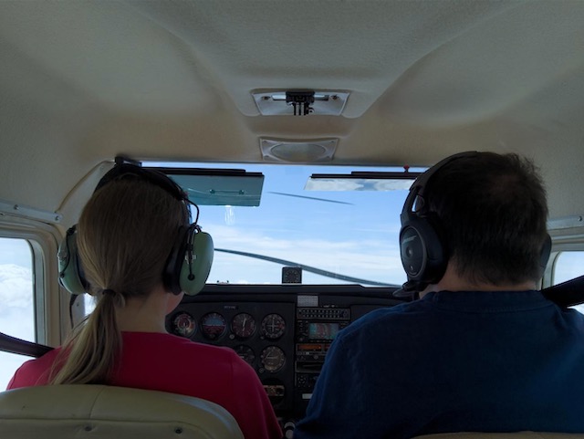
One of the great things about flying this day were my companions! I had a great co-pilot who is working on his instrument rating and handled our ATC communications for practice (with me monitoring of course, since I’m responsible for the flight in this setting). I really enjoy flying as a team! We also had a passenger in the back taking his very first flight in a small plane. He took a lot of pictures and seemed to enjoy the thrill of ducking in and out of clouds too!

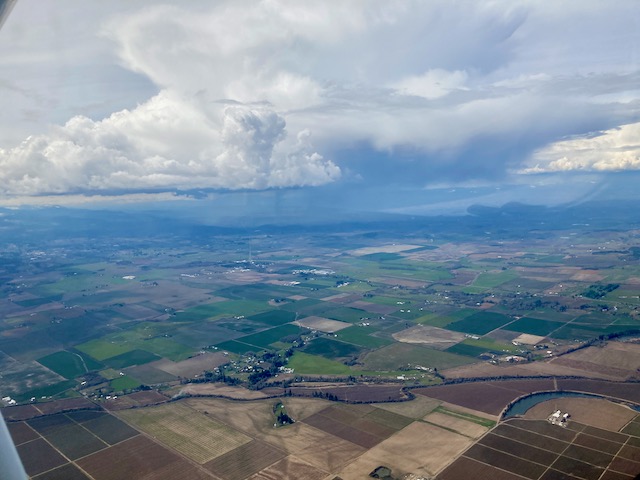
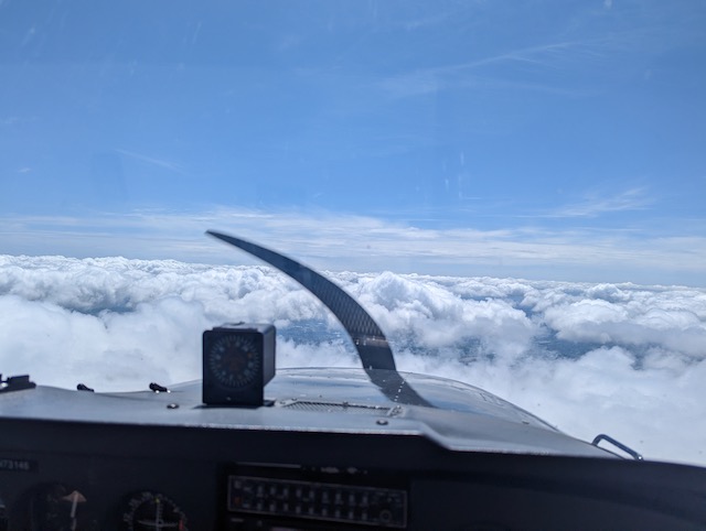
Looking forward as we returned southbound, above the clouds at 5000′:

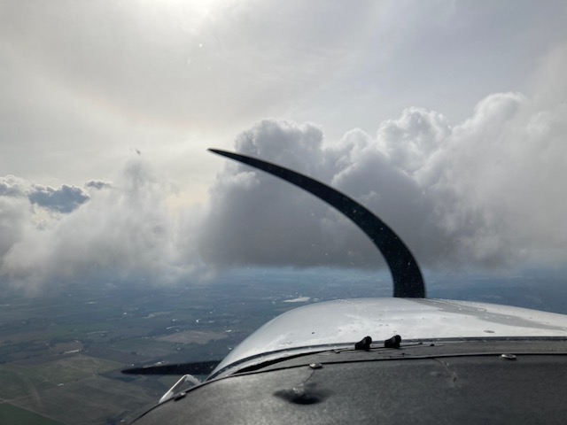
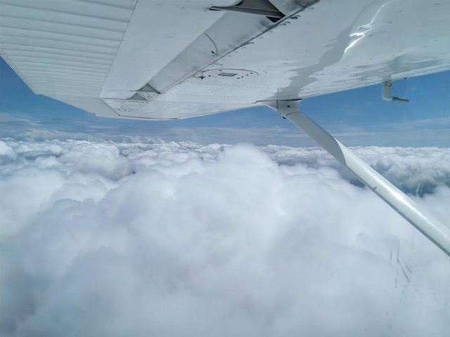
Looking out to the side:

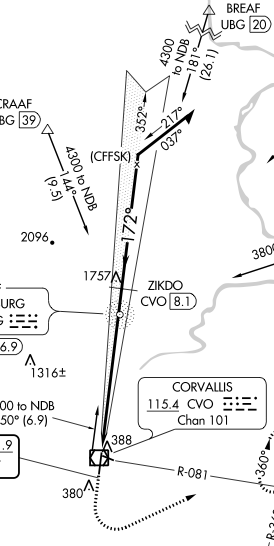
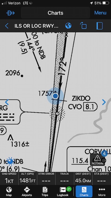
We returned to KCVO via the ILS 17 approach from SKIVE (a new waypoint for which apparently some folks say “skive” and others say “skeevy”). Once down through the clouds, we canceled IFR and crossed over midfield to land on runway 28.

One of the challenges of this flight was that with three people in the plane, it was near max gross weight. I did extra-careful fuel calculations and we were able to go with half-full tanks, but even so the plane’s performance in terms of climb rate and cruise speed was definitely lower than usual. However, it was a great flight, and I just love getting to sail through the clouds and maintain proficiency with instrument flight. Looking forward to next time already!

When thunderstorms get in your way (in flight)

On March 22, I went up for some practice instrument flying with a fellow instrument-rated pilot. We headed up to McMinnville (KMMV), about a 30-minute flight. There were a few puffy clouds scattered around, but (somewhat disappointingly) nothing directly in our path, so Ryan put on his foggles and I served as the safety pilot. I watched for traffic, kept an eye on the scattered clouds, and enjoyed the view, while Ryan had to stare at the instruments and miss all the scenery.

Here’s my view of some puffy clouds away to the west (Ryan flies from the right seat):

As we flew further north, I spotted this less friendly looking cloud with vertical development and active rain. I kept an eye on it, but we were flying well to the east so it wasn’t an immediate concern.

We reached McMinnville (which was clear) and Ryan flew two approaches under the hood while I continued spotting other planes and monitoring clouds to the south and west of the airport. Originally we were going to switch so I could also fly an approach, but it seemed to me that the weather was closing in a bit so we decided to head back to Corvallis. As we returned, Ryan got to fly us into this little cloud (isn’t it stunning?) and then we were clear again.

I took the controls (and the comm), lowered my foggles, and we were cleared back to Corvallis. Now Ryan was scouting for traffic and clouds. At one point he said we’d gotten back in some clouds, so I got to flip up my foggles and enjoy seeing clouds in front of the plane’s nose (I bet that sight never gets old!). Then I was back to staring at the instruments. This was the first time I’d used this plane’s autopilot, and it was a good chance to get familiar with its operation.

After a bit, ATC notified us that there was an “area of severe precipitation ahead, 10 miles wide, say intentions.” That didn’t sound good, and when we tuned in to Corvallis’s weather reporting, we heard “wind 290 at 13 gusting 20, thunderstorms”. We looked at the NEXRAD display and saw that the thunderstorm was sitting just east of our destination (here, south is up and the storm is the yellow/orange blob) – right where we wanted to go to land on the runway most favored by the winds (RW 28).

We may fly into clouds, but we do not fly into thunderstorms. I’ve rescheduled a return flight before to avoid them. I’ve never had to deal with them in flight, though. After some discussion of options, I asked for a hold at DERAY, which is a waypoint on the RNAV 35 approach and looked to be far enough south to keep us well clear of the storm. The lines on the screen aren’t our track – they’re the approach, which would take us uncomfortably close to the storm. The hope was that if we circled in the hold at DERAY for a bit, the storm would move on or dissipate, clearing the way for our approach. We had plenty of fuel for this. And indeed, after 10-15 minutes in the hold, the storm had faded and I proceeded in and down towards runway 35. It wasn’t my best approach (I was too high, but better than being too low I guess! I’ll do better next time), but I successfully crabbed into the crosswind and then circled to land on 28 (winds were from 290 at 19 gusting 23, whee). That was my 75th instrument approach!

While everything worked out fine, I was a little perplexed that this thunderstorm came as a surprise. I’d gotten a weather briefing, and there were no thunderstorm warnings (otherwise I would not have flown that day). The only clues were an area of “general convective activity” over most of western Oregon, with no supporting details, and “rain showers” forecast (but rain showers do not always, or even usually, turn into thunderstorms).

After the flight, I looked up the hourly weather reports from Corvallis that had been ticking by while we were out at McMinnville. When we left at 2:30 p.m., winds were from 140 at 7 knots, clear skies. At 3 p.m. it was reporting “LTG DSNT N” (distant lightning to the north). Later reports show the thunderstorm beginning at 3:45 p.m. and ending at 4:41 p.m. We landed at 4:51 p.m.

I also considered what I would do differently if this came up again. I would have asked ATC for vectors to keep us further west of the storm on our way to DERAY. I didn’t notice any turbulence from it, but the standard advice is to stay 20 NM away, and we were closer than that. And if the storm didn’t move or dissipate, we could have diverted to Eugene, which was experiencing clear weather and is quite close.

Overall, this was another reminder that no matter when and where you fly, there’s always something new to learn. Flying is never boring, and I love the continual challenge of it!

Hunting for aviation obstacles

I may have invented a new sport!

Airplane instrument approaches to airports allow you to fly safely through clouds (or in the dark) without running into terrain or obstacles. They specify the path to fly and the minimum altitude for each segment. Individual obstacles (hills, towers, etc.) are also charted as an additional warning for things to avoid.

KCVO ILS 17One example is the ILS approach to runway 17 at the Corvallis (KCVO) airport. An excerpt is shown at right. You fly along the thick black line from top-to-bottom on this chart (with a heading of 172 degrees) to get to runway 17, which is near the icon marked with the “CVO” bubble (this is actually the VOR but it’s close to the approach end of RW 17).

If you look near the point marked “ZIKDO”, you can see a little pointy icon with “1757” next to it. This indicates an obstacle (tower) that sticks up to 1757 feet above sea level. The procedure specifies that your airplane should be no lower than 2800′ here, and the obstacle shows you exactly why. It’s comforting to know that you have 1000′ of clearance above the highest obstacle as you’re flying along at 100 mph without being able to see the ground.

I have flown this approach several times, and I’ve always either had my foggles on or been in the clouds, so I’d never actually seen the obstacle. It was more of a theoretical entity.

ILS17The other day I was out for a hike and realized that the path I was on went right under the ILS 17 approach course. In fact, as I hiked up a hill, I realized that I might be approaching whatever that tall obstacle must be. I pulled up my Garmin Pilot app (generally used when I’m flying, not hiking) and was able to navigate to the ground location of the obstacle near ZIKDO! The blue dot shows my location. The app reports I’m standing at 1481′, so (depending how accurate that is), the tower would be about 275′ tall.


And here is what I found: an impressively tall tower sticking up on top of the hill and certainly not something I’d like to have in close proximity to my airplane:

Tower

It was so cool to see it with my own eyes! Locating the obstacle felt a little like an aviation-themed geocaching exercise :) There was no tangible treasure to be found, but now the instrument approach procedure chart feels a little more “grounded”, and I can appreciate all over again the work that goes into formulating these approaches to keep us safe. There’s more to find on this chart alone! I already know the one at 388′ just north of the airport (it’s a water tower, very cool). Maybe sometime I’ll make my way to the tower at 1316′, the hill/mountain at 2096′, or the tower indicated at 380′ south of the airport. Here’s to finding more aero-obstacles!

Instrument rating checkride

On February 15, 2023, I took my instrument rating checkride with Lisa Dahl at the Salem, OR, airport (KSLE). That morning, my home airport (KCVO) was covered in thick freezing fog, so I couldn’t fly my plane there as originally planned. Instead, I drove to KSLE and then handed my car keys to an instructor who was kind enough to drive my car to KCVO and fly the plane back to KSLE for me, while I did the oral part of the checkride. We started the oral part at 10 a.m. and finished around 2 p.m. (when the plane showed up), ate a bit of lunch, then went flying for 2 more hours.

Overall, the oral part of the exam was very conversational, and Lisa encouraged me from the start to take notes so I would know what to look into more deeply after the checkride. That was something I’d wanted to do anyway!

Lisa checked my documents, endorsements, and qualifications (training and experience), quizzed me about IFR currency requirements, and discussed my personal mins (guidelines for conditions under which I’d feel comfortable flying IFR). We reviewed the airplane’s inspections and airworthiness and talked through some decision-making scenarios.

In advance, she’d asked me to plan an IFR flight from KSLE to KRBG (Roseburg, in the hills), then pick up a passenger and fly KRBG to KCEC (Crescent City, on the coast). This was a fun exercise, and I’d spent a lot of time compiling all the details I would want if I were really flying it (route, altitude, weight and balance, fuel requirements, estimated time en route, whom I’d talk to along the way, departure and approach procedures available, takeoff mins, my personal mins, runway properties (including lighting), airport services, NOTAMs, the latest weather that day, special concerns, and alternatives (if no-go on the flight). I brought Google 3D visualizations of the expected approaches to give a visual sense of the terrain (especially KRBG). Most of this we didn’t actually use, but we did talk about en-route altitudes and terrain clearance.

Planned flight KSLE to KRBG to KCEC

We talked through decision making in scenarios like being in the clouds and discovering you have icing on your plane, or turbulence, and what options you would consider. We looked at KONP (Newport) and how its airspace differs from KCVO’s airspace. We discussed being cleared for a “visual” approach and what that means, then talked through the RNAV B approach at KRBG. I shared my concerns about the steep descent rate required (a VDA (visual descent angle) of 5.36 degrees which is almost twice the typical 3 degrees).

Next we talked about the airplane’s electrical system: battery voltage, bus voltage, alternator failure, how long the battery might last, and that transitioned nicely to a discussion of what to do if you have lose communication. She asked if I would accept a tailwind landing and seemed pleased I had articulated a personal limit for this.


Apparently the oral part was satisfactory, because we proceeded to discuss a plan for our flight. We separated to eat our lunches, then I went out to pre-flight the plane. She joined me and asked a few questions about the plane (cylinders, spark plugs, fuel vents). She had me handle ATC communications while we were IFR and she took over when we were VFR. We flew the SLE4 departure from runway 34 (they gave us a heading of 340 and 4000′). During debrief later, Lisa said not to do a rolling takeoff, which was the first time I’d gotten that advice. (Instead, get on the runway and lined up, pause, final check of heading/runway/etc., then proceed). I’ve only done this for short-field takeoffs. Good to know!

She wanted me to demonstrate one hand-flown approach, one autopilot-coupled, and the other one my choice. We flew the ILS 31 from LOTKE, missed approach, hold at ARTTY, then the LOC BC 13, circle west to a low approach on RW 34. I used the autopilot after departure until we were approaching LOTKE, hand-flew the ILS 31, used the autopilot for the hold and LOC BC 13, then hand-flew everything else. She complimented my handling of approach speed and descent rate. Here I am reporting that we’re coming in on the ILS 31:

and then when we crossed the LOTKE waypoint:

and then when we went missed and were climbing away from the airport:

For the LOC BC 13, after leveling nicely just above MDA, I flipped up the foggles and started inadvertently descending (I think maybe due to the slight disorientation in switching from foggles to visual and simultaneously slowing down – pitching up and reducing power, maybe too much on the latter) and she said to watch altitude, and I quickly caught it. My alignment downwind was good, but in looking at my ground track I judge that I was way too far from the runway. The low approach went well and we climbed out VFR.

We did a sequence of VOR tuning and tracking operations, then everyone’s favorite: unusual attitude recoveries! We returned to the airport with the RNAV 31 approach. We simulated loss of WAAS, so no vertical guidance, and she put a post-it over the HSI to simulate the loss of one G5, so I also had limited lateral guidance. I flared a little high but it was a satisfactory landing. We taxied back to parking and she said that I passed!

Overall it was a great opportunity to go through all of the knowledge and skills that I’ve been working for months to acquire. Lisa gave me what I consider an enormous compliment in saying that I ask all the right questions and she likes how I get into the details of how things work. She encouraged me to get my commercial and CFI certificates and train some students :) I then flew back to KCVO, landing a bit after 7 p.m.!

The real reward for passing the checkride will be getting to fly instruments without foggles on! I can’t wait to see what I’ve been missing!

Flying in the clouds

I’ve now gotten the chance to fly inside the clouds a few times. It is a breathtaking experience! Most of the time, instrument training is done in “simulated” conditions in which you wear blinders (“foggles”) that block out everything but the instrument panel. But there are still small clues like the feel of the sun on your arm or the slant of shadows, and maybe there’s always a sense in the back of your brain that you COULD remove the foggles if you really WANTED to.

Taking off and plunging into a dense, gray cloud with your eyes wide open feels a lot different. There is a “fwoosh” moment on entry – I’m not sure if it’s actually audible or just the mental experience of being enveloped and losing all visual references. The temperature drops, sounds seem a little different, and you think, “Okay, this is for REAL.” 90% of your brain gets busy processing the instruments which are now your only lifeline, while 10% sits in the back thinking “I’m hurtling through the air at 100 mph and I CAN’T SEE.” You have to suppress that part of your brain. :)

Then you observe that it isn’t that different from all the practice you’ve been doing. The plane still responds the same and you’re still tracking your GPS course or VOR needles or other navigational aid. However, it *can* get more bumpy, and now you need to remember to look outside every now and then – not because you can see anything of use for navigation, but to check for any signs of ice accumulating on your airplane.

The first time I flew into the cloud, it was a benign layer sitting above the airport that we tunneled through on the way up and then back down, up, down doing practice instrument approaches. The second time, the clouds were piled up unevenly at our altitude so we flew in and out of them horizontally, getting spatterings of rain and finding small pockets of clear air (but cloud below) before we plunged into the next gray wall. The in-and-out was a little distracting, plus the plane took a little more management, but it was great to see various ways that clouds can manifest for real.

I look forward to getting more experience with clouds. Certainly not all of them are clouds you want to fly into, but knowing how to handle reduced visibility is an excellent skill to have.

Older entries »