September 24th, 2017 at 5:34 pm (Technology, Travel)
Recently on a trip to Ireland, in an effort to reduce my cellular data consumption, I put my phone into airplane mode while driving across the country. Imagine my surprise when, an hour later, I checked my phone and found that it was still correctly reporting my location, and giving me directions!
I scratched my head about this for a little while. The moving map was updating my position even in airplane mode! It was also scrolling the map as I moved. So it must be the case that
- Google Maps downloads and caches enough information that it can continue to show you the relevant map info even if it loses a data connection to its server, and
- The GPS receiver in the phone continues to operate in airplane mode.
 This had never occurred to me! I was able to confirm it at other times during the trip. If you try to get directions from Google Maps when in airplane mode, it doesn’t work – you can’t search the maps. But if you get the directions started, then go into airplane mode (i.e., turn off cell data), then it will correctly continue to give you directions. However, if you deviate at all, it cannot re-route you, so you have to figure that out for yourself.
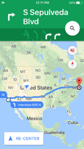
I decided to test this during a recent cross-country flight. Right before a flight from Los Angeles to Philadelphia, I got driving directions from Google maps (see right; it wants me to start on Sepulveda Blvd) and then I put the phone into airplane mode.
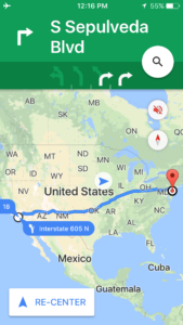
A few minutes after takeoff from LAX, we were out over the ocean and Google Maps was still urgently telling me to get onto Sepulveda Blvd:

I checked on the directions periodically throughout the 5-hour flight.

Each time we had made some more progress, but we were so far off the (road) track that Google Maps kept saying to go back to Sepulveda Blvd and start over.

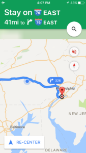
As we got close to the Philadelphia airport, we were close enough to match up with a road (briefly) and the directions made more sense.

So cool! This means that even when an airplane doesn’t bother to give you that awesome moving-map track of where the plane currently is, you can still get it, IN AIRPLANE MODE, on your phone! (But only if you got some directions first.)
Comments
January 15th, 2017 at 10:53 pm (Flying, Travel)
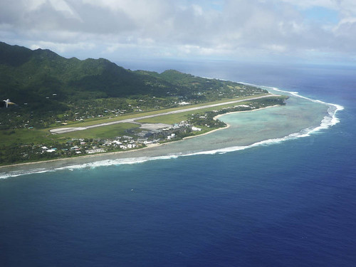
 The Rarotonga International Airport (RAR) has a runway that is 7,638 feet long.
I am flew there on a 777-200. That seems like a rather short runway for a big jet. I’ve landed on longer runways myself (like San Bernardino or Ontario). Curious, I looked up the minimum runway length for a 777-200. According to the Air Cyber Alliance, it is 8,563 feet. Yes, that is longer than the Rarontonga runway. Eeek?
Minimum runway lengths are dictated by how much space the plane needs to take off (which is generally longer than the space needed to land. Yes, this means planes can land somewhere and then be unable to take off again). The minimums are calculated for the aircraft when fully loaded, at max gross weight. So one way to take off in less distance is to reduce the load – fewer passengers, less cargo, or less fuel.
According to the seat map, my return flight is nearly or completely full of passengers, so they won’t go that route. And they can’t skimp much on fuel: the flight from RAR to LAX is quite long (4,688 miles, 10 hours) and the 777-200 has a maximum range of 5,240 miles when fully fueled. Plus, you don’t just take exactly enough fuel to get there; you need extra fuel in case you have to divert or circle or otherwise go out of your way. So maybe they just reduce cargo?
I noticed that they schedule return flights to depart close to local midnight – probably trying to use the coolest part of the day to improve the plane’s performance. And by “coolest”, I mean 78 F. Challenging for flying. I want to chat with these pilots!
Comments
December 29th, 2016 at 1:45 pm (Travel, Weather)
 I am heading to the Cook Islands in a few weeks to explore the island of Rarotonga. This is a tiny island, covering 26 square miles and with a population of 10,000, in the south Pacific.
To prepare for the trip, I have been monitoring the weather out there. This is their rainy season, so it’s getting pounded with thunderstorms (eek!). I’m hoping it will clear up a bit before my trip.
In addition to thunderstorms, I noticed the weather report on the UV index, which has been varying from 7 to 9 during the day. At first I thought maybe the max value was 10, but then saw it go up to 11. So I looked up what exactly the UV index is. I learned that it doesn’t have a max value! It’s a measurement of the amount of “sunburn-producing UV radiation”, so it focuses on the amount of radiation in the 295-325 nm range. It is unitless, and the range is linear (so a UV index of 10 is twice as strong as 5). It was originally designed so that 10 would correspond to typical noontime summer (max) sunlight. However, this was established in 1992, and since then, higher and higher values have been observed, up to the world record of 43 (!!!) in 2003, although that value is contested and might “only” be 26.
Wikipedia’s guidelines suggest that one should limit midday exposure if the UV index is anywhere over 3, and over 6 yields “high risk of harm from unprotected sun exposure.” If it gets over 11, “unprotected skin and eyes can burn in minutes.” So, time to break out the sunscreen and protective clothing… unless I’m stuck indoors due to thunderstorms :)
1 Comments
1 of 1 people learned something from this entry.
September 13th, 2011 at 10:32 pm (Music, Sports, Travel)
Last weekend, I took the train north to Olympia, WA, to visit my friend Marcy. She put together an action-packed weekend with tons of new experiences and fun times. The list of “firsts” for me included:
- Eating Voodoo Doughnuts that I picked up in Portland during the train’s stopover there, at Marcy’s suggestion. My favorite was the butterfinger one. Yum!
- Attending a punk house show (that’s when a collection of bands show up at someone’s house, set up in the living room, and play for the benefit of a group of strangers who’ve also shown up). Imagine a house painted completely black (with some wood trim), decorated with things like a poster of Shirley Temple with “SHIRLEY’S FIRST BLACK EYE” written on it, a slouched crowd of smokers out on the stoop, and punk music booming from inside. A sign on the bathroom door urged you to pee outside. There were three bands that evening, the best one being TacocaT — aside from scoring points for their palindromic name, they write cute/edgy songs mainly from a girl perspective. Check them out!
- Playing Urban Golf through the streets of Olympia. This involves dressing up in your best argyle, tweed, or houndstooth and hitting nerf balls with golf clubs on a predefined course. Marcy and I set up the course she’d scouted by duct taping squares of astroturf (to tee off from) and then marking “holes” to aim the balls into. It was an absolutely hilarious time. We got lots of strange looks but only a few comments, and no one called the police. Hooray!
- Waving my hand through the water of Puget Sound to trigger bioluminescence. This is completely awesome. Too bad the water’s so cold. I can only imagine how phenomenal it would be to SWIM while glowing blue!
- Attending a rock concert in hipster bar. I only recently learned what a hipster was! But this place apparently sold the right beer and attracted people with the right fashion sense. The highlight of the evening was a Japanese band called Mugen Hoso, which consisted of two too-cute Japanese guys in the middle of their “BIG BANG! BANG! BANG!” tour. They’d driven 40 hours from Austin, TX, to arrive 5 hours before this concert, but were buzzing with energy and played their hearts out. So charming, so rockin’, so cute!
- Climbing up on a bench to escape a moshing crowd. At first I thought Mugen Hoso had inspired some massive brawl, but it turned out that the people were intentionally slamming into each other and apparently enjoying it. Beer quickly slicked the floor, and it got harder to pay attention to the band. Even though I had a great view from the bench, I had to be ready to catch and push back on random bodies that came flying at the bench. Headbanging I’d seen before, but this? Wow.
- Picking blackberries and eating them with vanilla ice cream. Mundane for many, perhaps, but a marvelous treat for me :)
 Attending a roller derby match. I didn’t know anything about roller derby, so was grateful to have an informed friend along! Basically, it’s two teams of super-athletic women racing to score points by passing the other team’s members around the rink. It’s quite a spectacle, with players decked out in fishnets and face paint, but what really steals the show is the amazing skating (on old-fashioned four-wheel skates, no less). Olympia has a world-class team, and they demolished their opponents from Cincinnati with a final score of 299 to 81! (Check out this picture from the match.)
- Watching salmon prepare to head upstream, and seeing a “fish ladder” that helps them get past a dam. Wow, those salmon are huge! We also saw seals swimming around them ready to catch a meal, and blue herons winging all over — beautiful.
- Cutting someone else’s hair. I got to use a comb and scissors, just like a pro! Marcy is a brave, brave woman.
- Attending a party where I was the only one without a tattoo. Well, okay, I think Marcy is also tat-less, but we were definitely the only ones. Turns out that tattoos don’t keep people from wanting to play croquet, though!
- Mutton Bustin’. Technically I didn’t actually get to see this, although we did call up some videos. Marcy and I met up with a high school friend of mine who talked about how her son had just won 3rd place in a Mutton Bustin’ competition at the fair. This is a sport in which small boys are put on sheep (yes, sheep), then the sheep is tickled and prodded into a frenzy, and then they are let out into a yard where the boy tries to cling to the sheep and not get bucked off. Wow!
- Being in a comic strip. That’s right, one of Marcy’s friends who also golfed with us, Chelsea Baker, is an illustrator and comic artist. She created this summary of Urban Golf, and I ended up in it!

That’s me with the hat and argyle sweater over my shoulders.
Now that’s an incredible, learning-filled weekend!
Comments
September 10th, 2011 at 8:09 am (History, Travel)
Yesterday I had the pleasure of riding the Coast Starlight train north from Albany, OR, to Olympia, WA. As always, I was entranced by the stunning views, the vast comfortable ease of travel, and what interesting things there were to learn and see. From Portland north to Seattle, the train has volunteers from the National Park Service who sit in the observation car and offer interesting bits of history or explanations about what you’re seeing outside those huge picture windows. This is brilliant! I learned a variety of interesting tidbits:
- Portland got its name as the result of a coin flip. The two founders, Asa Lovejoy and Francis Pettygrove, each wanted to name it after their favorite back-East city, respectively Boston and Portland (Maine). They flipped a coin and Pettygrove won. (Speaking of names, ever wonder how Oregon got its name? The wikipedia article on this is disappointingly inconclusive, but the various hypotheses are interesting.
- A Columbia River drawbridge was open when we arrived, so we had to wait for it to finish letting some ship through. The Columbia has been dredged multiple times to permit the passage of deep-sea ships up it.
- The Coast Starlight’s running speed is 75-79 mph. (It doesn’t feel that fast because it’s so smooth and quiet on the inside!) That speed limit is dictated not by the trains but by the track system, which was designed to accommodate the (much slower) freight trains. Apparently if the CS ran any faster, it would outpace the signaling system (e.g., the triggers prior to an intersection that sound the bells and lower the gates).
- Wheat grown in Washington is soft/winter wheat, mainly used for noodles and doughnuts. 90% of it is shipped to the East. Wheat from Montana is harder (heartier?).
- As a southbound train went by, full of grain cars, our guide commented that each train car holds 100 tons of grain; there are 110 cars in 1 train; and the contents of 6.5 trains fill 1 ocean carrier.
- We passed several artificial mounds and hills as we passed through Washington, which are formed from clearing ash from the 1980 Mt. St. Helens eruption. Ash had to be scraped off of hundreds of miles of roads and tracks.
Now I’m in Olympia, where more things to learn await. :)
Comments
 This had never occurred to me! I was able to confirm it at other times during the trip. If you try to get directions from Google Maps when in airplane mode, it doesn’t work – you can’t search the maps. But if you get the directions started, then go into airplane mode (i.e., turn off cell data), then it will correctly continue to give you directions. However, if you deviate at all, it cannot re-route you, so you have to figure that out for yourself.


