Getting to Earth orbit is hard

Recently I enjoyed working through Coursera’s Rocket Science for Everyone taught by Prof. Marla Geha.

The course reminds us that achieving orbit is all about going horizontally fast enough that you “miss” the Earth’s surface. For our planet’s mass, to achieve low Earth orbit, that speed is about 7.6 km/sec. I was interested to learn that given our available chemical propulsion options, we almost didn’t make it to orbit.

The rocket equation defines the change in velocity (delta_v) that you get from a given fuel and rocket design:

delta_v = v_exhaust ln(rocket mass [initial] / rocket without fuel mass [final] )

Exhaust velocity (v_exhaust) is how fast material is pushed out of the rocket, given the fuel you are using. This value for our propellants is about 2-3 km/sec, which means you need something greater than 95% fuel in order to get to 7.6 km/sec and achieve low Earth orbit! (By making that natural log of the mass ratio large enough)

Fortunately, smart people figured out that you can work around this limit using multiple stages and discarding spent containers to improve your mass ratio as you go. But if our planet had been more massive, we would have had to get a lot more creative to find something that would work.

Another bonus: launching near the equator and west to east gives you 0.5 km/sec for “free” (if you want an equatorial orbit). But Vandenberg Air Force Base (not equatorial) is a good launch site if you want a polar orbit instead (no freebies).

I also learned that GPS satellites are not out at geostationary orbit (which would allow them always to be in view, and only require three total to cover the Earth) because they didn’t want to have to build ground stations for them all over the Earth (i.e., in other countries) but instead just in the U.S. Interesting.

Great class – I recommend it!
Where old friends go when the mission is over

Recently I visited the Smithsonian Air and Space Museum on the Mall for the first time. I lost myself in the aviation section for a couple of hours, learning all sorts of interesting things about the history of our airlines, flight attendants, airmail, aircraft development, and even a board game for instrument flying!

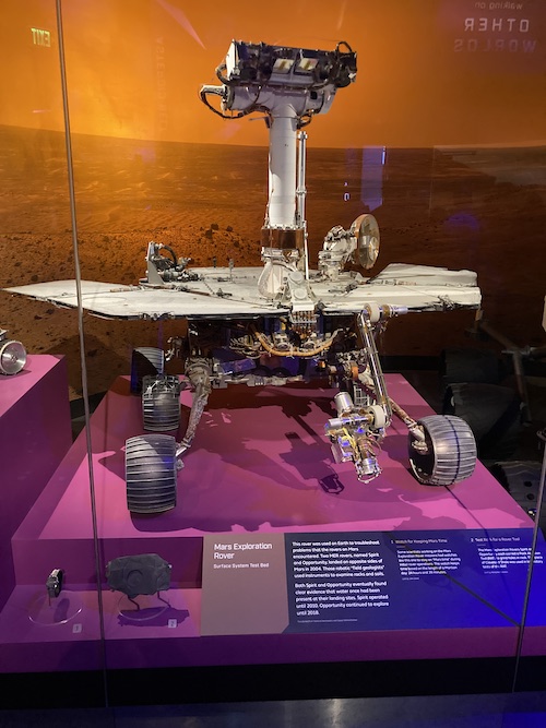
Then I went into the exhibit dedicated to our planets and was immediately drawn to the Mars section. It featured three examples of our Mars rover lineage, increasing in size from Sojourner to the Mars Exploration Rovers to the Mars Science Laboratory rover.

“Huh,” I thought, “They didn’t bother to mock up solar panels for the Mars Exploration Rover.”

I stared at its blank grey deck for a few more seconds before I remembered where else I’d seen a Mars Exploration Rover with no solar panels: at JPL, where I worked on the planning team for the Mars Exploration Rover Opportunity. While Opportunity was at Mars, we had a twin rover here on Earth in the Mars Yard (or the In-Situ Instrument Laboratory) where we could try out command sequences before sending them to Mars. That rover, too, did not have solar panels because it was powered by a cable that plugged into the wall.

I squinted more closely at the display and found that it identified this object as the “Surface System Test Bed” (SSTB) which meant that IT IS EXACTLY THE TEST ROVER that we used at JPL during mission operations. Confirmed: in 2019, which was after both Mars Exploration Rover missions had ended, the MER SSTB was sent to the Smithsonian.

And what better place, really, for such a unique artifact? Even if it totally took me by surprise. I think the other museum-goers were surely puzzled by the sight of a woman standing in front of the Mars rovers and crying.

Big data in 1981

Browsing the JPL archives, I came across this image from 1981 for the Voyager 2 mission’s encounter with Saturn. It was designed to illustrate how Voyager 2 would be sending back soooooo much data – look how many books it makes! (Click to enlarge)

Voyager 2 data
Image credit: JPL Photolab, 1981.

I love that in 1981, the artists measured data in terms of books :) Not many people had their own computers or would have understood a discussion of disks or files or bits or bytes, so this was the perfect visualization. Even today, I find it more charming and tangible than most “big data” graphics I’ve encountered.

Cassini has, rightfully, gotten a lot of press lately for its gorgeous images of Saturn, but Voyager 2 was there first and captured its own beauties, like this one:

Pick your prime meridian

On Earth, the line of zero degrees longitude runs through Greenwich, England. What about other planets?

Unlike latitude, longitude has no physically defined starting point. Zero degrees of latitude is at a planet’s equator and is easy to establish from the body’s rotation (although as noted by Wikipedia, technically it also depends on the “reference ellipsoid” chosen to model the body). In contrast, zero degrees of longitude can be wherever you want it to be. However, change it with caution: any modifications mean that all of your previous maps and published locations have to be updated!

This happened on Mars. Originally (1830), the line of zero degrees was set to be a point in a dark region that was 40 years later named (due to its utility) Sinus Meridiani (get it?).

In 1969, it was decided to change the prime meridian to go through a specific crater named Airy-0 (a smaller crater inside a bigger one named Airy). This was thanks to the higher resolution images that the Mariner 9 spacecraft generated, enabling the selection of a smaller, more precise, reference point. Each time we send higher resolution cameras to Mars, we get to see more and more details of this crater:


Airy-0 (top crater in each image) as seen by (A) Mariner 9 in 1972,
(B) Viking 1 in 1978, and
(C) Mars Global Surveyor in 2001.

However, this crater is still large enough (500 m across) to not be a very satisfying reference point to measure distances to other features. If you use a yardstick to measure that distance, where inside Airy-0 should one end of your stick go? You want your reference point to be as small as possible so that everyone measures distance the same way.

What do we have on Mars that is very small but very recognizable? Our landers!

But we don’t want to pick a new prime meridian. If we did, we’d have to change all our maps and localized data — a huge and infeasible task.

Instead, Mars cartographers did something very clever. They kept Airy-0 as the 0 point, then carefully calculated the longitude of the Viking 1 lander with respect to the center Airy-0. Why that lander? Because it’s been there the longest, so it provides a consistent reference point for all data going back to 1976. At the time Viking 1 landed, its location was known only to within 0.1 degree (~6 km). Its location is now known much more precisely. I was unable to find the exact number, but it’s at least an order of magnitude better. So today, all longitudes of Mars surface features or objects can be calculated with reference to the Viking 1 lander (at 48.222 deg W, not 0), enabling much higher precision in localization!


Viking 1, the lander that keeps on giving

This issue has become even more challenging with the discovery of exoplanets – including some for which we are starting to make maps. How shall we pick their prime meridians, without being able to see surface features?

Does the Earth rise, seen from the Moon?

Perhaps you have seen this iconic photograph, taken by Apollo 8 astronaut William Anders in 1968:

It is an arresting view: our Earth, seen from the outside. But not just from afar: from another place in space. The lunar landscape gives it a certain awe-inspiring context. How small our Earth looks against the vast stretch of the lunar horizon!

Yet despite its beauty, this photo has irritated me for some time. It is titled Earthrise, a poetic and yet almost entirely misleading name.

How many people have seen this photo and come away thinking that the Earth rises on the Moon?

How many still think that?

The Earth was not rising. The Moon is tidally locked with the Earth, which means that it always points the same face at the Earth. From the Moon’s perspective, the Earth would hang at a fixed point in the sky, depending where you stood on the Moon’s surface. (From the far side, you would never see it.)

However, the astronauts were not standing on the surface but instead in orbit around the Moon, so from their perspective, the Earth came shooting up over the horizon, an artificial Earthrise.

BUT WAIT!

That’s not quite right. Today I learned that the Earth isn’t entirely stationary in the lunar sky, because it (the Moon) librates (wobbles) a little bit back and forth, which makes the Earth appear to move slowly, subtly in the sky, over the course of a month. Perhaps more interesting to the observer is the fact that, from the Moon, the Earth goes through phases (as shown above).

China’s Yutu rover recently captured its own “Earthrise” shot, which includes the lander, and the Earth in a different phase:

Orbital geometry aside, these photos are just breathtaking. And the idea of our blue planet rising, sailing overhead, and then setting is such a dramatic and captivating one! But not reality. As you now know.

Older entries »